Ground Truthing & Calibrating Imagery Obtained from UAVs
This article is taken from the Malvern Panalytical blog, authored by Susan Parks, Remote Sensing Manager for ASD.
The use of Unmanned Aerial Vehicles (UAVs – also known as “drones”) is growing rapidly in the field of remote sensing as a new and versatile tool for data acquisition in areas such as agricultural resource monitoring, soil characterisation, and environmental monitoring. Specific examples where sensors mounted on UAVs have provided useful results include water stress detection in agricultural crops, plant biomass and nitrogen content in crops and grasses, yield forecasting for crops like wheat and rice, rangeland management, leaf area index and vineyard management.
UAVs fill the gap between satellite imagery and ground-based spectroradiometers. One of the main benefits of UAVs is that their low operating height enables the generation of very high spatial resolution imagery data for small areas, with some systems capable of reaching resolutions of 1 cm per pixel. UAVs also can have a shorter revisit period than satellite platforms and offer high temporal resolution and increased manoeuvrability to allow access to previously inaccessible areas or hazardous environments. Another benefit of UAVs is the low operational costs compared with other methods.

Spectral imagery collected from a sensor mounted on a UAV requires similar methods as satellite and fixed-wing airborne sensors and in terms of ground-truthing activities; meaning that radiometric calibration is necessary for the extraction of quantitative data from the image pixels. Factors that affect the data include weather conditions and the characteristics of the sensor being used. However, unlike satellite and fixed-wing aerial sensors and given that UAVs are flown at relatively low heights (e.g. 30 metres), many studies suggest that there are few atmospheric effects on UAVs; this can really simplify the workflow for correcting the imagery data provided by the UAV-mounted spectral imager.
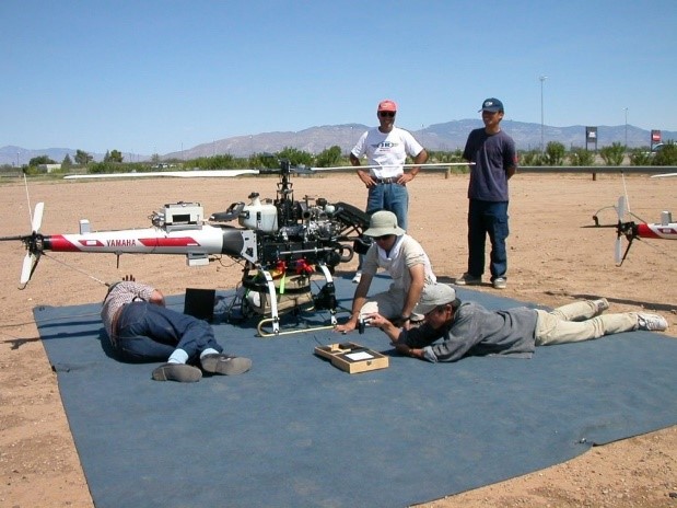
(Right) An ASD instrument on a UAS/mini-helicopter for the purpose of collecting airborne remote sensing measurements.
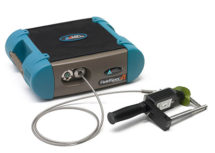
As with all remote sensing activities, good quantitative data requires that the sensors are characterised and validated against reference measurements from ground-based spectroradiometers such as the ASD FieldSpec 4 instruments. Validating against reference measurements is required in markets like precision agriculture which require thorough calibration procedures, high-quality characterisation and the ability to work well in the field – this also applies to satellite and fixed-wing airborne imagery. Using an ASD FieldSpec 4 to collect field measurements is the best method to create a calibration model using an empirical line method approach to correct the data.
An ASD FieldSpec spectroradiometer is used to collect spectra on the ground to provide a measure of true surface reflectance for the ground-based targets selected by the user. The spectra typically then needs to be down sampled to match the wavelength ranges of the imaging camera system being used.
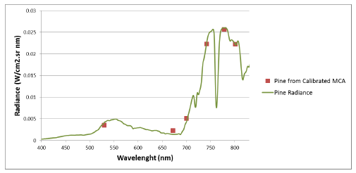
An example of this is shown in the results from a study by Del Pozo et al. (2014) that compares the spectrum collected by an ASD FieldSpec (the green line) versus the data collected in a multispectral imager with 6 bands mounted on a drone (the orange squares), for a pine tree after applying calibration coefficients to correct the imagery data derived from ground truth data.

The sampling method for ground-truthing with an ASD FieldSpec varies from study to study, but generally, several reference spectra are collected for each ground-based target (10 samples is often a good number). The spectra from the ASD FieldSpec are produced in ASD file formats that can either be ingested into a remote sensing package, if supported or can be converted to an ASCII format before ingesting. Once in a remote sensing analysis software package, the data files need to be down sampled to match the wavelength ranges (or bands) of the imaging sensor and then an empirical line method can then be applied in order to establish band-specific calibration coefficients.
The coefficients are then applied to each target material using the empirical line method on a pixel by pixel basis. This allows the digital numbers of the image pixels to be converted to surface reflectance.
The calibration of spectral sensors is a key component of getting good quantitative data.
The ASD FieldSpec 4 Series

The FieldSpec 4 is a fast, precise and truly field-portable spectroradiometer designed by researchers, for researchers to perform solar spectral reflectance, radiance, and irradiance measurements.This market-leading instrument offers ASD’s state-of-the-art remote sensing technology with dramatically improved speed, performance and portability over previous models.


