Analytik report on how the National Physical Laboratory applies the ASD FieldSpec 4 in their measurements of vegetation to compare with satellite observations
 Analytik report on how the National Physical Laboratory applies the ASD FieldSpec 4 in their measurements of vegetation to compare with satellite observations
Cambridge, UK, 29th September, 2015: Analytik, leading suppliers of innovative analytical instrumentation, report on how the National Physical Laboratory applies the ASD, a PANalytical company FieldSpec 4 analyser to study vegetation to compare with data recorded from satellites.
The Environmental Division of the National Physical Laboratory (NPL) has a group which specialises in the investigation of the quality of Earth Observation satellite data. The TREES group (TRaceability in tErrestrial vEgetation Sensors and biophysical products) aims to provide end-to-end traceability for terrestrial vegetation sensors and satellite-derived products of biophysical Essential Climate Variables (ECVs) through a range of research activities.
The group has recently used a FieldSpec 4 System in a field site characterisation study being conducted in Wytham Woods, Oxford. The ASD spectroradiometer was used to provide the spectral properties of individual foliage, understory and bark to input into a 3D radiative transfer model. The spectral information will be combined with data from other optical instruments (including a LiCORs, TRAC-2 and digital hemispherical photography as well as ground LiDAR) over a 6 ha study area to model forest structure and other biophysical parameters such as leaf area index (LAI).
Describing the motivation for the use of a system such as the FieldSpec 4, group member, Alexandra Barker, takes up the story. “We needed to make in situ measurements of the canopy foliage, tree bark, understory vegetation and soils to provide a spectral library of the woodland components. This information will aid the development of a realistic 3D model of the field site that will in turn provide traceable reference information for satellite product validation studies. The portability and durability of the FieldSpec 4 system was a key factor for its inclusion in our field campaign. It makes fast, accurate spectral measurements so that a representative sample of different species could be taken quickly and easily over the field site.”
The FieldSpec 4 will be used at a number of field sites from deserts to forests to aid field site characterisation and traceability exercises. This is part of the overall program of the Earth Observation and Climate Group at NPL which is involved in all aspects of satellite data calibration, validation and quality assessment.
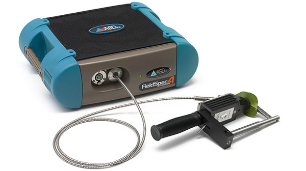
The FieldSpec 4 is an extremely flexible spectroradiometer having a variety of test configurations which are suited to field work. In tests described above, a specially developed leaf clip was used to look at the foliage; a pistol grip was used to look at the understory (in ecology, this is the plant life growing beneath the forest canopy); finally, a contact probe was used to test the bark. The range of FieldSpec instruments can be tailored to the needs of the researcher and this played an important part of the NPL’s decision to make it part of their test instrumentation kit.
To find out more about Analytik and their range of spectral imaging, portable and handheld spectroscopy systems, please visit: http://www.analytik.co.uk/.